Precision Data from Above.
Turning Aerial Imagery into Actionable Intelligence.
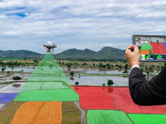
Qualitas Global provides specialised, high-accuracy aerial imaging and surveying annotation services, transforming drone, satellite, and LiDAR data into the structured insights your computer vision models need.
The Power of Annotated Aerial Data
We expertly label and segment aerial data, enabling your AI models to accurately identify objects, measure distances, and track changes across vast geographical areas. We provide the precision data foundation for your geospatial and remote sensing projects.
Key Annotation Techniques We Master
Our experienced annotators handle the complex geometries and resolutions unique to aerial datasets:
Semantic Segmentation: Colouring every pixel in an image to classify ground cover for accurate land-use mapping.
Object Detection (Bounding Boxes): Drawing precise boxes around assets of interest, such as vehicles, infrastructure, livestock, or construction equipment.
3D Point Cloud Annotation (LiDAR): Labeling millions of data points captured by LiDAR sensors for accurate digital twin creation, volume calculation and obstacle detection for autonomous aerial systems.
Orthomosaic and Satellite Imagery: Preparing large, stitched images for machine learning applications, including change detection and military intelligence.
Applications Across Key Industries
Our high-quality aerial data annotation accelerates AI development in critical sectors:
Why Partner with Qualitas Global for Aerial Annotation?
Expertise in Geospatial Data: Our teams are trained to understand spatial coordinate systems, projection methods, and the quality requirements for GIS and CAD environments.
Scalability: We efficiently manage terabytes of large-format aerial data, ensuring rapid turnaround times without sacrificing accuracy.
Quality: Our multi-layered process is built to handle the differences in aerial imagery to deliver industry-leading annotation accuracy.
Solar Panel Annotation
For our Solar Panel Annotation services, we utilized Polygon Annotation to precisely identify & label solar panels in aerial images & drone footage videos. This manual annotation process involved outlining & labeling the solar panels in the footage & generating annotations that served multiple purposes including object detection, monitoring & analysis of solar panel installations.
Urban Houses Annotation
For our Urban Houses Annotation services, our team made use of bounding box annotation on urban houses using satellite images & visual GPS data, focusing on outdoor residential images. This process involved outlining & labeling bounding boxes around the houses, facilitating various applications such as urban planning, real estate analysis & infrastructure development.
Disaster Management Annotation
For our Disaster Management Annotation services, our team annotated drone images taken in disaster-affected areas. We outlined & labeled key elements for efficient disaster response & recovery using bounding boxes. Our annotation also included classes such as Debris, Damaged infrastructure, Evacuees, etc. Our services help resources like fire responders to understand the level of damage & organise ways to manage the disaster.
Site Monitoring Annotation
For Site Monitoring Annotation services, we use bounding box annotations to track, label & manage equipment, safety hazards & project progress at construction sites. Our annotation encompasses classes like Cranes, Excavators, Bulldozers, etc. Almost all such videos & images are captured by drones.
Traffic Flow Optimization
In Traffic Flow Optimisation services, we annotate using key point & bounding box annotation on drone & aerial images to identify & label traffic signs, signals, lane markings & congested areas. These annotations support traffic flow analysis, road planning & intelligent transportation systems, improving overall road network efficiency & safety.
Military Surveillance
For Milirary Surveillance annotation on drone images involves marking objects of interest such as vehicles, aircrafts & vessels. Actions like troop movement, suspicious behaviour & vehicle convoys are also included. This annotated data currently assists in training the model to automatically detect these classes.